
Sale


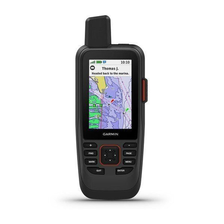
Garmin GPSMAP86sci Handheld GPS with inReach BlueChart G3 U.S.With Sensors Built-in BlueChart G3 CoastalCast off confidently with the GPSMAP® 79s marine GPS handheld. This rugged, floating handheld features a sunlight-readable, high-resolution color display that is fogproof and scratch-resistant. You get access to a range of satellite constellations, so you get more reliable, accurate tracking around the world. Navigate wherever your adventures take you with the worldwide basemap. With more memory than previous models, you can save and track 10,000 waypoints and 250 routes. Keep your bearings with the built-in compass.This handheld is water-resistant (IPX7) with a high-resolution color display you can read in the sun. The glass is even scratch-resistant and fogproof.If rough waters come and the handheld goes overboard, don’t worry. This device floats.User-replaceable AA batteries (not included) provide up to 19 hours of battery life in GPS tracking mode.With support for multiple satellite constellations — such as GPS, GLONASS, Beidou, Galileo, QZSS and SBAS — you’ll get accurate, reliable tracking and positioning around the world.More memory than previous models means you can save and track 10,000 waypoints, 250 routes and 300 fitness activity files.The 3-axis tilt-compensated electronic compass shows your heading — even while the boat is standing still.Preloaded BlueChart g3 coastal charts (GPSMAP 79sc only) give you leading-edge coverage, clarity and detail with integrated Garmin and Navionics data.Model: 010-02635-02• Rugged, floating, water-resistant (IPX6 — unit level only) handheld GPS with a high-resolution color display and scratch-resistant, fogproof glass• Increased memory to save and track 10,000 waypoints, 250 routes and 300 fit activities• Supports multiple satellite constellations (GPS, GLONASS, Beidou, Galileo, QZSS and SBAS) for reliable tracking around the world• Includes worldwide basemap• Built-in 3-axis tilt-compensated electronic compass shows heading while standing still• Barometric altimeter tracks changes in pressure to pinpoint your precise altitude• Battery life: up to 20 hours in GPS modeWhat's in the Box:• GPSMAP 79s• Lanyard• USB Cable• DocumentationCast off confidently with the GPSMAP 86sci handheld. Whether you’re out for a day of fishing, sailing or cruising, you’ll gain peace of mind that comes from having a backup navigator with satellite communication and interactive SOS. This premium handheld floats and has a sunlight-readable 3" color display. Plus, wireless connectivity makes it a virtual extension of your onboard marine system, giving you added awareness and convenience.Sync GPSMAP 86sci with compatible Garmin chartplotters and instruments, and you’ll see real-time boat data displayed right on your handheld. Plus, it can serve as a remote control for convenient operation of your Garmin autopilot and select FUSION marine products. And when you’re underway, an adjustable GPS filter smooths speed and heading indications over swells for more accurate tracking.With built-in inReach satellite technology and additional service options , GPSMAP 86sci helps you stay in touch globally. Send and receive two-way text messages, track and share your journey, and, if necessary, trigger an interactive SOS to get emergency help from a 24/7 global monitoring center via the 100% global Iridium® satellite network. You can also receive marine weather forecasts directly on your device, so you can make educated decisions based on local conditions or the destination ahead.GPSMAP 86sci comes preloaded with BlueChart g3 coastal charts, giving you industry-leading coverage, clarity and detail with integrated Garmin and Navionics data. Detailed contours allow you to see 1’ contours that provide a more accurate depiction of bottom structure for improved fishing charts and enhanced detail in swamps, canals and port plans.Get smart notifications right...


