


Garmin BlueChart® g3 Vision® HD Oslo-Skagerak-Haugesund - microSD™/SD™
Garmin
$249.99
(No reviews yet)

Write a Review
Garmin
Garmin BlueChart® g3 Vision® HD Oslo-Skagerak-Haugesund - microSD™/SD™
Garmin BlueChart® g3 Vision® HD Oslo-Skagerak-Haugesund - microSD™/SD™
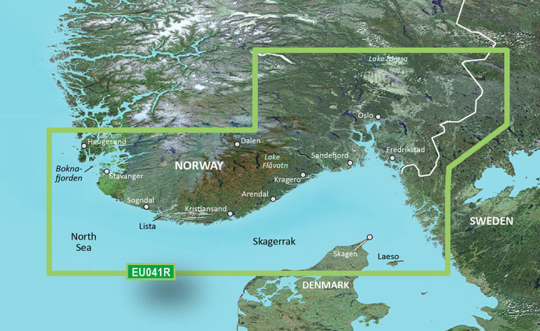
BlueChart® g3 Vision® HD - VEU041R - Oslo - Skagerak - Haugesund - microSD™/SD™
Coverage:
Covers the Norwegian and Swedish coasts from Flekkefjord, Nor. to Göteborg, Swe., including the Norwegian cities of Kristiansand, Skien, Drammen, Oslo, and Halden. Also includes coverage of the northern most tip of Denmark including Skagen and Frederikshavn, as well as the island of Laeso.
Premier Coastal Charts
- Industry-leading coverage, clarity and detail with updated coastal charts that feature integrated Garmin and Navionics® content
- Auto Guidance¹ technology quickly calculates a suggested route by using your desired depth and overhead clearance
- Includes Depth Range Shading for up to 10 depth ranges, enabling you to view your target depth at a glance
- Up to 1’ contours provide a more accurate depiction of the bottom structure for improved fishing charts
- To give a clear picture of shallow waters to avoid, the Shallow Water Shading allows for shading at a user-defined depth
Experience unparalleled coverage and brilliant detail when you’re on the water. BlueChart g3 Vision coastal charts provide industry-leading coverage, clarity and detail with integrated Garmin and Navionics content.
Auto Guidance
Whether you are fishing or cruising, select a spot, and get a route showing you the general path and nearby obstructions at a safe depth1.
Depth Range Shading
This feature displays high-resolution Depth Range Shading for up to 10 depth ranges so you can view your designated target depth.
Shallow Water Shading
To give a clear picture of shallow waters to avoid, this feature allows for shading at a user-defined depth.
Detailed Contours
BlueChart g3 Vision charts feature 1’ contours that provide a more accurate depiction of bottom structure for improved fishing charts and enhanced detail in swamps, canals and port plans.
High-resolution Satellite Imagery
High-resolution satellite imagery with navigational charts overlaid gives you a realistic view of your surroundings. It’s our most realistic charting display in a chartplotter — ideal for entering unfamiliar harbors or ports.
FishEye View
This underwater perspective shows 3-D representation of bottom and contours as seen from below the waterline. Interface with sonar data for a customized view.
MarinerEye View
This view provides a 3-D representation of the surrounding area both above and below the waterline.
Aerial Photography
Crystal-clear aerial photography shows exceptional detail of many ports, harbors and marinas and is ideal when entering unfamiliar ports.
¹Auto Guidance is for planning purposes only and does not replace safe navigation practices
WARNING: This product can expose you to chemicals which are known to the State of California to cause cancer, birth defects or other reproductive harm. For more information go to P65Warnings.ca.gov.
This product may not be returned to the original point of purchase. Please contact the manufacturer directly with any issues or concerns. Fast Shipping We get your order shipped out within 2-business days and delivered to your doorstep as quickly as possible. Competitive Pricing With our dynamic pricing model, our prices are always competitive. Our prices are some of the lowest that you will find on the internet. Rest assured that you're getting a good deal when purchasing with us. 30-day Money Back Guarantee We are committed to making sure that you leave this transaction satisfied. If you're unhappy with the product for any reason, you may return it back for your money-back or a replacement within 30 days, just return it in the same condition we sent it to you. No questions asked!-
-
-
Sale
-
-


